Home › Stories › The Pleasure House
What is the ruin on the cliff above Hartland Quay?
Climb up from Hartland Quay and the first thing you see is a ruin on the skyline, with a big arch. Google Maps gives it one name, its listing another, and Hartland Abbey's own map a third. The dates people give it run from the 13th century to the Victorians. A Hartland historian, in a book published in 1940, called it "somewhat of a mystery". I went looking.
Skip to conclusions
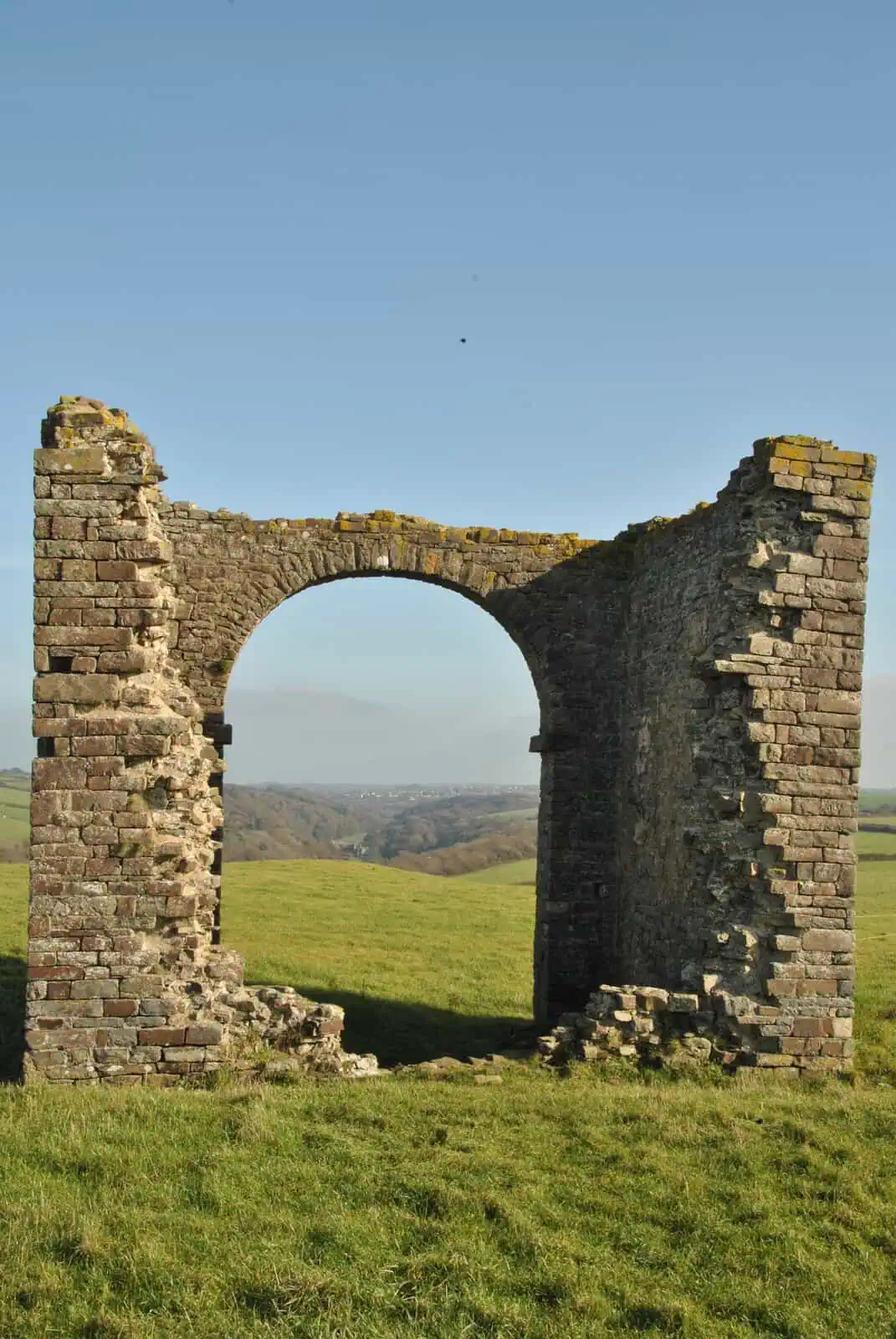
It's the Pleasure House. It's a listed building: on 19 June 1989 it was added at Grade II to the national list of protected historic buildings, as "Folly known as the Pleasure House". Country Life used the name in 1983, and Historic England says it goes back to a letter of 1738. R. Pearse Chope, in The Book of Hartland (1940), says the Revd James Hervey wrote a 1738 letter from the Pleasure House itself, probably the one Historic England means. Google Maps has called it Warren Lookout Tower since about late 2024, and I couldn't find that name in a book, a map or a historic record.
Ways to see it
- A short walk Climb the steps from the Quay to the clifftop: it's the first thing you see.
What you see
Climb up from the Quay to the clifftop and it's the first thing in front of you. On the coast path north, it comes into view as soon as you're past the Rocket House, the glass-fronted house on the corner by the toll booth.
From the road you get a glimpse: a gate about 6 m before the toll booth looks across the Warren to it. But from there you're looking at its north wall, plain stone, small at that distance. It could be a shed. Walk round to the seaward side and you'll see why it's listed.
Stand in the big arch and look east. Stoke's church tower and, beyond it, Hartland Abbey sit almost in one line.
Between it and the sea stands a fingerpost with four arms: Padstow and Land's End one way, Wales and Lundy the other. No distances, just the places.
It hasn't always looked like this. R. Pearse Chope, a Hartland historian, saw "obvious marks of extensive alterations". His Book of Hartland (1940) records a second storey with a fireplace, traces of a staircase in the plaster, and openings either side of the big arch, since built up.
A 1983 Country Life caption reads: "The arch of the Pleasure House can be seen on the skyline beyond."
The names, one by one
The Pleasure House. This is the name on the listing. Buildings in England are listed when they're judged to be of special architectural or historic interest. In 1989 the list was kept by the Department of the Environment; Historic England keeps it today.
Country Life used the name in 1983, and Headley and Meulenkamp's Follies, the National Trust guide, in 1986. The history board at the Quay calls it "The Pleasure House folly".
Historic England says it's "first mentioned by that name in a letter of 1738". The 1986 book dates the name to a map of 1738 instead. Chope doesn't take sides, but he gives a letter: he says the Revd James Hervey wrote to his sister in 1738 "from the Pleasure House on the Warren", and quotes the letter from Richard Polwhele's History of Devonshire. That points to a letter; it doesn't rule out a map. Whether Hervey's own words use the name, I haven't yet seen.
The folly. The 1989 listing's title calls it a folly, and Hartland Abbey's estate map labels it simply "FOLLY".
The Warren. That's the field it stands in, not the building. The tithe survey of 1842 (the parish's survey of land for tithe payments) calls the field "Cliff Warren", and the Ordnance Survey map of 1884 "The Warren". The Ordnance Survey maps I looked at, from 1884 to 1964, draw the building but don't name it.
Warren Lookout Tower. This is what Google Maps shows, so it's probably the name on your phone. The Google place carries photos from November 2024. I looked for the name in the listing, the old maps, Devon's Historic Environment Record, the Abbey's material and the newspapers, and didn't find it.
Not Dyer's Lookout. That's a separate point on the cliffs about 500 m north, named on Ordnance Survey maps since 1884.
Four dates
The Hartland Peninsula Association's heritage walk leaflets call it probably a 13th-century warrener's house. Historic England says it's possibly late 16th century, remodelled in the later 18th. The North Devon Coast National Landscape's page calls it a Victorian folly.
Chope's Book of Hartland (1940) says it "shows no signs of antiquity". He judged it most likely built early in the 18th century by the first Paul Orchard, of the family who owned the Abbey, possibly as an artificial ruin: a building made to look old and broken on purpose, as was the fashion.
Those are the four dates I could find for when it was built. Chope gives a reason; the leaflets and the National Landscape cite no source. Historic England lists three sources behind its entry (Chope's The Book of Hartland, Rix and Meyers' Hartland Quay and Country Life), but its date doesn't match Chope's, and it doesn't say where it comes from. It also says the building is first shown on an early 18th-century map of the Abbey.
One more clue. Chope says a drawing of the Abbey by Henry de Cort, who exhibited at the Royal Academy from 1790, apparently shows the building as a ruined church with a tower, which he put down to the artist's imagination. The heritage leaflets' note that "some drawings show this as a church" may refer to it, or to other drawings I haven't seen.
What was it for?
Six tellings, and who tells them.
- Probably a belvedere, a building put up for the view, by the Abbott family before 1738 (Headley and Meulenkamp, Follies, 1986).
- The second Paul Orchard (1739 to 1812), who inherited Hartland Abbey, is said to have made the big arch so he could back his coach in for shelter (Chope, 1940: "It is said"). Historic England has it differently: he's "reputed" to have altered it to back his carriage in and admire the view.
- An artificial ruin, built to look old on purpose, by the first Paul Orchard early in the 18th century (Chope, 1940, who says "possibly").
- A warrener's house, the home of the man who kept the rabbits, with a clear view across the Warren against poachers (the heritage walk leaflets).
- A two-storey lookout house, watching for pirates, smugglers and ships arriving at the Quay, converted into a folly towards the end of the 18th century as part of a grand landscape design for Hartland Abbey (the history board at the Quay). The National Landscape also calls it a lookout for pirates.
- A summer house, and later a "Romantic Ruin" that set off the view from the Abbey (the heritage walk leaflets).
Different sources, different stories, and no consensus.
Where I looked
I started with the 1989 listing, then went to the old Ordnance Survey maps, from 1884 to 1964, and the parish tithe survey. I read Devon's Historic Environment Record, Hartland Abbey's website and the heritage walk leaflets it hosts, and the hotel's site at the Quay. I searched the newspaper and magazine archives, and the map and photo sites where names get added by the public.
Then a second researcher checked the trail, source by source. Their corrections are on this page.
Then the book arrived. R. Pearse Chope's The Book of Hartland answered more in an afternoon than the web had in two days. And when I went back to my own photo of the history board at the Quay, the name had been on it all along: "The Pleasure House folly".
What I'll read next
The next lead is Hervey's own letter. Chope quotes it from Polwhele's History of Devonshire, and I want to see whether Hervey himself calls it the Pleasure House. After that, the Hartland Abbey papers and their catalogue.
The Book of Hartland is on this page now. Chope's other Hartland book, Farthest from the Railways, is next. When it answers anything, this page will say so.
Walk to it
From the middle car park at the Quay, the one with the old boat, take the steps up beside the road to the Rocket House, where the coast path north begins; from the top car park it's right beside you. The Pleasure House is ahead. The Blegberry circular passes it on the way north.
Know more?
If you know what it was for, or you've seen Hervey's letter or the 1738 map Headley and Meulenkamp mention, I'd like to hear from you.
Sources
- My visit and the walk, 31 October 2026; Google Street View (captured October 2021).
- Historic England, list entry 1333133: Folly known as the Pleasure House (listed 19 June 1989).
- Ordnance Survey 25-inch, Devon XVII.9 (1884), and 1:10,560 SS22NW (1964), via the National Library of Scotland.
- Hartland tithe award (1842) and apportionment (1846), plot 1041.
- Devon Historic Environment Record, MDV37676.
- G. Headley and W. Meulenkamp, Follies: a National Trust guide (1986), p.15.
- R. Haslam, "Hartland Abbey, Devon II", Country Life, 15 September 1983.
- R. Pearse Chope, The Book of Hartland, edited by Isobel Thornley (1940; facsimile published by Hartland Parochial Church Council for St Nectan's Church, 1995), pp. 64–65, quoting Richard Polwhele, History of Devonshire, vol. 3, p. 419n.
- Hartland Abbey, map of the grounds; Hartland Peninsula Association, heritage walk leaflets.
- North Devon Coast National Landscape; the history board at Hartland Quay (photographed 31 October 2026).
- Google Maps, the place labelled Warren Lookout Tower (viewed 5 November 2026).
Last checked on the ground: 31 October 2026.